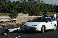
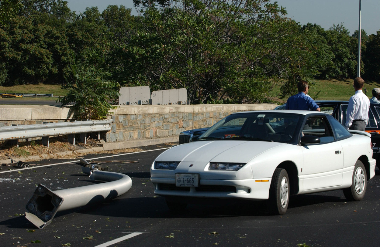
 Picture
one shows cars on Route 27 that were damaged by light
pole debris. The poles were clipped by the aircraft as it passed
overhead of Route 27 on its way to strike the Pentagon. The pole to
the left is one of several that were clipped by the aircraft. The
pole is also not complete, you can see it was sheered at the top.
Look through the windshield of the white compact and you will see
the damaged windshield of the cab in shot 1-1. Picture
one shows cars on Route 27 that were damaged by light
pole debris. The poles were clipped by the aircraft as it passed
overhead of Route 27 on its way to strike the Pentagon. The pole to
the left is one of several that were clipped by the aircraft. The
pole is also not complete, you can see it was sheered at the top.
Look through the windshield of the white compact and you will see
the damaged windshield of the cab in shot 1-1.
|
 Picture
1-1 is a close-up of the cab's damage. Picture
1-1 is a close-up of the cab's damage.
|
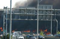 The
second shot was taken before the first and from the area of the
Navy Annex (the plane come over the top of the Annex on its way
across Route 27 and into the Pentagon). You can see the Pentagon on
fire from the initial strike and the building is still standing.
The small white car is the same from picture one. Some of the fires
in this picture are vehicles that were parked by the helo pad that
are on fire. The
second shot was taken before the first and from the area of the
Navy Annex (the plane come over the top of the Annex on its way
across Route 27 and into the Pentagon). You can see the Pentagon on
fire from the initial strike and the building is still standing.
The small white car is the same from picture one. Some of the fires
in this picture are vehicles that were parked by the helo pad that
are on fire.
|
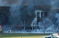
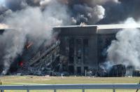
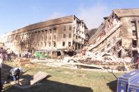
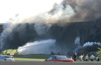 The
third picture is when the first fire truck (from National
Airport) arrived and started its initial suppression efforts. To
the right you can see the diesel generator trailer (used to power
the control tower at the helo pad) on fire and the darker smoke as
the diesel fuel tank exploded and is fueling fires in that area.
Above the trailer you can see a white area of fire suppression foam
on the building right where the 4th corridor exits. You also notice
that the building is severely damaged as you can see the shift in
the granite facing, this is one of the hinge areas many see in later
photos posted elsewhere. Note that the grass and grounds of the
area are not gouged or disturbed. Recall that in the Khobar Towers
bombing, where a 20,000lb truck bomb took the face off of the
dormitory and killed 19 US Airmen, it truck bomb left a crater over
85 feet wide and some 25 feet deep. There is no such crater
present. Also note at the bottom of the picture, the concrete
"jersey" barrier behind the red car. Looking to the front of the
jersey you see the grey top of the guard rail that surrounds the
Pentagon on Route 27, it too has not been breached, meaning no truck
rammed through it to drive up to the building to detonate a vehicle
or truck borne explosive. The
third picture is when the first fire truck (from National
Airport) arrived and started its initial suppression efforts. To
the right you can see the diesel generator trailer (used to power
the control tower at the helo pad) on fire and the darker smoke as
the diesel fuel tank exploded and is fueling fires in that area.
Above the trailer you can see a white area of fire suppression foam
on the building right where the 4th corridor exits. You also notice
that the building is severely damaged as you can see the shift in
the granite facing, this is one of the hinge areas many see in later
photos posted elsewhere. Note that the grass and grounds of the
area are not gouged or disturbed. Recall that in the Khobar Towers
bombing, where a 20,000lb truck bomb took the face off of the
dormitory and killed 19 US Airmen, it truck bomb left a crater over
85 feet wide and some 25 feet deep. There is no such crater
present. Also note at the bottom of the picture, the concrete
"jersey" barrier behind the red car. Looking to the front of the
jersey you see the grey top of the guard rail that surrounds the
Pentagon on Route 27, it too has not been breached, meaning no truck
rammed through it to drive up to the building to detonate a vehicle
or truck borne explosive.
|
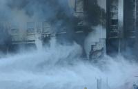 Picture
4 is a closer view of the hinge area of corridor 4 mentioned
previously. You can clearly see the fire suppression foam's loosing
battle against the aviation fuel. You also see the support columns
still holding the building together. The windows above are intact
because they're special blast proof windows designed to defeat a
large explosive - they worked well. The special windows were
installed during the renovation of the 4th corridor wedge by
strapping them directly into the original structure. You'll see
these windows in many of the published pictures. You are primarily
focused on the second floor of the building in this shot, the first
floor is obstructed by the stream of foam. Picture
4 is a closer view of the hinge area of corridor 4 mentioned
previously. You can clearly see the fire suppression foam's loosing
battle against the aviation fuel. You also see the support columns
still holding the building together. The windows above are intact
because they're special blast proof windows designed to defeat a
large explosive - they worked well. The special windows were
installed during the renovation of the 4th corridor wedge by
strapping them directly into the original structure. You'll see
these windows in many of the published pictures. You are primarily
focused on the second floor of the building in this shot, the first
floor is obstructed by the stream of foam.
|
 Picture
5 shows a view from the intact Route 27 guardrail. The fire
truck has run out of suppression foam and water. You see some of
the secondary fires are out (like the vehicles to the truck's left,
but the fires still rage inside the building still. You can see the
hinge area to the right and the sagging support columns along the
base of the building (REMEMBER: The building is five stories, but
on the outside E-Ring, the 5th floor does not have windows). You
can also see the pressure on the building by looking at the
difference in roof heights from the left side to the right. The
remaining columns are holding an immense amount of weight while at
the same time being weakened by the 1600+ degree fires. You can see
the difference in the size of the hinge area to the right from
previous photos. Just above the man's head and to the right you can
see the plane's impact hole that continues from the fire burning on
the second floor and extends to the left through the smoke and haze. Picture
5 shows a view from the intact Route 27 guardrail. The fire
truck has run out of suppression foam and water. You see some of
the secondary fires are out (like the vehicles to the truck's left,
but the fires still rage inside the building still. You can see the
hinge area to the right and the sagging support columns along the
base of the building (REMEMBER: The building is five stories, but
on the outside E-Ring, the 5th floor does not have windows). You
can also see the pressure on the building by looking at the
difference in roof heights from the left side to the right. The
remaining columns are holding an immense amount of weight while at
the same time being weakened by the 1600+ degree fires. You can see
the difference in the size of the hinge area to the right from
previous photos. Just above the man's head and to the right you can
see the plane's impact hole that continues from the fire burning on
the second floor and extends to the left through the smoke and haze.
|
 Picture
6 is a different angle of shot 5. Note there are no truck
marks on the grass area, nor any crater that would have been caused
by a truck bomb. The responding "crash" fire truck didn't make any
marks on the grass because it uses a much wider and lower pressure
tire than a regular truck. That allows the vehicle's weight to be
spread over a wider area so the truck can go into many more areas
than a normal truck. This contrasts with a rigid and thin truck
tire that would tear grass upon turning, or make depressions due to
lack of asphalt support. You can see wire bundles and other items
in the picture left over from the wedge renovations. The diesel
trailer is to the right of the rightmost firefighter. The top left
of the photo shows how much buckling is taking place from the right
side hinge area to the left joint where the building is about to
fall. The fire above the wire bundles is the opening the aircraft
made upon impact. Picture
6 is a different angle of shot 5. Note there are no truck
marks on the grass area, nor any crater that would have been caused
by a truck bomb. The responding "crash" fire truck didn't make any
marks on the grass because it uses a much wider and lower pressure
tire than a regular truck. That allows the vehicle's weight to be
spread over a wider area so the truck can go into many more areas
than a normal truck. This contrasts with a rigid and thin truck
tire that would tear grass upon turning, or make depressions due to
lack of asphalt support. You can see wire bundles and other items
in the picture left over from the wedge renovations. The diesel
trailer is to the right of the rightmost firefighter. The top left
of the photo shows how much buckling is taking place from the right
side hinge area to the left joint where the building is about to
fall. The fire above the wire bundles is the opening the aircraft
made upon impact.
|
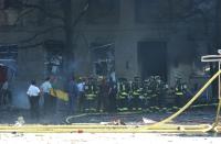
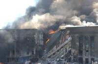 Picture
7 shows the E-ring building supports have failed and the
E-Ring in that area has collapsed. The backmost fires you see
raging are the fires from the collapsed roof that has failed and
folded back upon itself. Fires still rage in the rest of the
structure as well as inside the roofing. Look very closely at the
left wall sheer point (in the area where it is still standing), you
can clearly see where the second floor rear area of the E-Ring is
gone. That's the angle the plane took and the resulting damage.
Below that point and to the left is where the left engine and wing
area impacted and caused damage. That area also clearly shows
support columns' missing from where the aircraft engine's impact
sheered them away. Look at the green blast windows in the collapsed
area. They are those special windows that survived, and those
happen to be from the 3rd floor. Notice even in facility failure,
the windows are holding the face of the building and it's cross
columns together. Picture
7 shows the E-ring building supports have failed and the
E-Ring in that area has collapsed. The backmost fires you see
raging are the fires from the collapsed roof that has failed and
folded back upon itself. Fires still rage in the rest of the
structure as well as inside the roofing. Look very closely at the
left wall sheer point (in the area where it is still standing), you
can clearly see where the second floor rear area of the E-Ring is
gone. That's the angle the plane took and the resulting damage.
Below that point and to the left is where the left engine and wing
area impacted and caused damage. That area also clearly shows
support columns' missing from where the aircraft engine's impact
sheered them away. Look at the green blast windows in the collapsed
area. They are those special windows that survived, and those
happen to be from the 3rd floor. Notice even in facility failure,
the windows are holding the face of the building and it's cross
columns together.
|
 Picture
8 is similar but again showing the intact guardrail and
undisturbed grass. You can see the diesel trailer is still on fire.
Witnesses believed it was clipped and damaged by the right wing of
the aircraft. Picture
8 is similar but again showing the intact guardrail and
undisturbed grass. You can see the diesel trailer is still on fire.
Witnesses believed it was clipped and damaged by the right wing of
the aircraft.
|
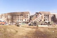 Picture
9 was taken after the fires on the E-ring had been
extinguished, but you can still see the smoke from the fires in the
roofing from the interior rings. You can see the amount of water
still present, as well as the heavy equipment starting to roll in
and bring shoring supplies so the threatened corner by the sheered
area can be propped up. You can also clearly see equipment in areas
where, if there were a truck bomb, there would be a huge crater.
You also see the tire marks the trucks are making in the grass. The
saturation of the grassy area by all the leaking and poured water
started to soften the area to the point where vehicles could have
become stuck and hampered the rescue efforts. There was a forecast
of rain for attack +2 that necessitated the building of sand and
gravel roads so all aspects of the rescue and recovery operations
could proceed. Anything less would have been unacceptable to the
families of the missing. Many believe the building of the roadways
was a cover-up for a crater or other reasons. If you look to the
left of the sheered area, you'll see (again) the missing support
columns where the plane impacted. Some of the hole is covered by
the boom of a light tower that is in the lowered position. Picture
9 was taken after the fires on the E-ring had been
extinguished, but you can still see the smoke from the fires in the
roofing from the interior rings. You can see the amount of water
still present, as well as the heavy equipment starting to roll in
and bring shoring supplies so the threatened corner by the sheered
area can be propped up. You can also clearly see equipment in areas
where, if there were a truck bomb, there would be a huge crater.
You also see the tire marks the trucks are making in the grass. The
saturation of the grassy area by all the leaking and poured water
started to soften the area to the point where vehicles could have
become stuck and hampered the rescue efforts. There was a forecast
of rain for attack +2 that necessitated the building of sand and
gravel roads so all aspects of the rescue and recovery operations
could proceed. Anything less would have been unacceptable to the
families of the missing. Many believe the building of the roadways
was a cover-up for a crater or other reasons. If you look to the
left of the sheered area, you'll see (again) the missing support
columns where the plane impacted. Some of the hole is covered by
the boom of a light tower that is in the lowered position.
|
 Picture
10 shows another angle of the same shot. You can see the
sheered area which is the left most entry hole the aircraft. Again,
no blast crater is present indicating a vehicle borne explosive. Picture
10 shows another angle of the same shot. You can see the
sheered area which is the left most entry hole the aircraft. Again,
no blast crater is present indicating a vehicle borne explosive.
|
 Picture
11 shows the helo pad to the left of the other shots. You
can see the plane's entry hole to the far right of the picture. You
can also see the severely burned fire truck (on the blast side) but
intact otherwise. The two firefighters had just finished waxing the
truck when they heard, then saw, the plane. They ran to the left of
this picture and were shielded from death by their very own fire
truck, which performed its last mission at that point by absorbing
the blast. This picture also starts to show the level of small
debris fragments that were the plane, and that cannot be seen in
other photos because of the depth of field of the pictures. I
speculate these parts were probably the remains of its left side
wing assemblies. There are similar amounts of small parts and
debris present throughout the entirety of the grass/helo pad area. Picture
11 shows the helo pad to the left of the other shots. You
can see the plane's entry hole to the far right of the picture. You
can also see the severely burned fire truck (on the blast side) but
intact otherwise. The two firefighters had just finished waxing the
truck when they heard, then saw, the plane. They ran to the left of
this picture and were shielded from death by their very own fire
truck, which performed its last mission at that point by absorbing
the blast. This picture also starts to show the level of small
debris fragments that were the plane, and that cannot be seen in
other photos because of the depth of field of the pictures. I
speculate these parts were probably the remains of its left side
wing assemblies. There are similar amounts of small parts and
debris present throughout the entirety of the grass/helo pad area.
|
 Picture
12 is a closer shot of the level of debris by the 5th
corridor side of the building. Picture
12 is a closer shot of the level of debris by the 5th
corridor side of the building.
|
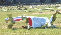 Picture
13 shows more of the debris field, including a twisted piece
of the American Airliner in front of the helo pad. Picture
13 shows more of the debris field, including a twisted piece
of the American Airliner in front of the helo pad.
|
 Picture
16 (and 17) are overhead shots of the building that shows
the impact area of the aircraft as well as the exit hole it made in
the C-Ring coming to rest in A&E Drive. The impact hole at the top
middle of the picture is clear. The exit hole is a bit trickier to
locate.
Start at the bottom right corner of the picture. Looking
at the row of windows from the corner, Picture
16 (and 17) are overhead shots of the building that shows
the impact area of the aircraft as well as the exit hole it made in
the C-Ring coming to rest in A&E Drive. The impact hole at the top
middle of the picture is clear. The exit hole is a bit trickier to
locate.
Start at the bottom right corner of the picture. Looking
at the row of windows from the corner, 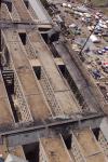 move left until you come to
the "trough" running between the rings. Go back to the right four
rows of windows and follow that down to the bottom floor (5, 4, 3,
2, then 1). You'll see a circular hole, that's the exit hole the
cockpit and front tire assembly made through the Navy Operations
Center. You'll note that the same areas to the right show no damage
on that ground floor. The open area to the right of the trough and
on the 1st floor is an area that was demolished to open another
avenue into the C ring, note that the hole is squared off to match
the exact size of the area between the support columns. move left until you come to
the "trough" running between the rings. Go back to the right four
rows of windows and follow that down to the bottom floor (5, 4, 3,
2, then 1). You'll see a circular hole, that's the exit hole the
cockpit and front tire assembly made through the Navy Operations
Center. You'll note that the same areas to the right show no damage
on that ground floor. The open area to the right of the trough and
on the 1st floor is an area that was demolished to open another
avenue into the C ring, note that the hole is squared off to match
the exact size of the area between the support columns.
|
 Picture
one shows cars on Route 27 that were damaged by light
pole debris. The poles were clipped by the aircraft as it passed
overhead of Route 27 on its way to strike the Pentagon. The pole to
the left is one of several that were clipped by the aircraft. The
pole is also not complete, you can see it was sheered at the top.
Look through the windshield of the white compact and you will see
the damaged windshield of the cab in shot 1-1.
Picture
one shows cars on Route 27 that were damaged by light
pole debris. The poles were clipped by the aircraft as it passed
overhead of Route 27 on its way to strike the Pentagon. The pole to
the left is one of several that were clipped by the aircraft. The
pole is also not complete, you can see it was sheered at the top.
Look through the windshield of the white compact and you will see
the damaged windshield of the cab in shot 1-1.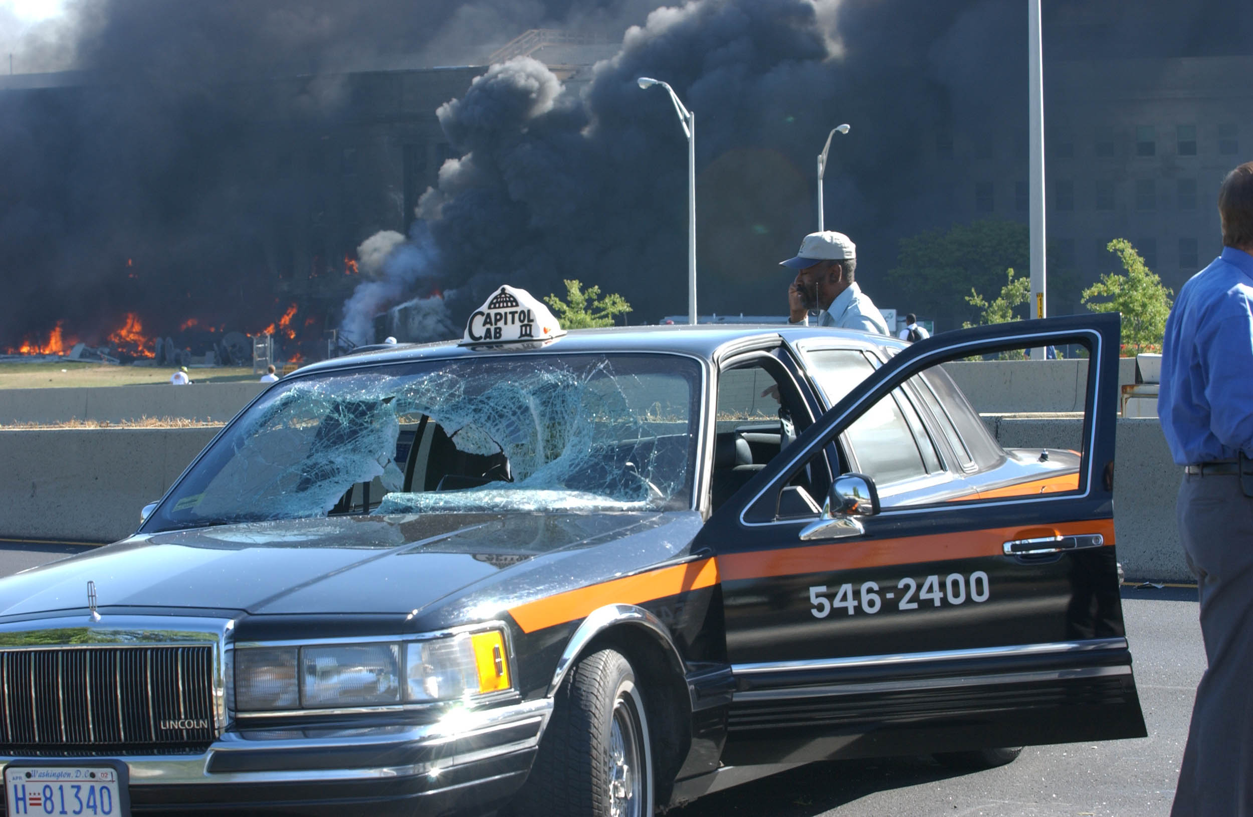 Picture
1-1 is a close-up of the cab's damage.
Picture
1-1 is a close-up of the cab's damage.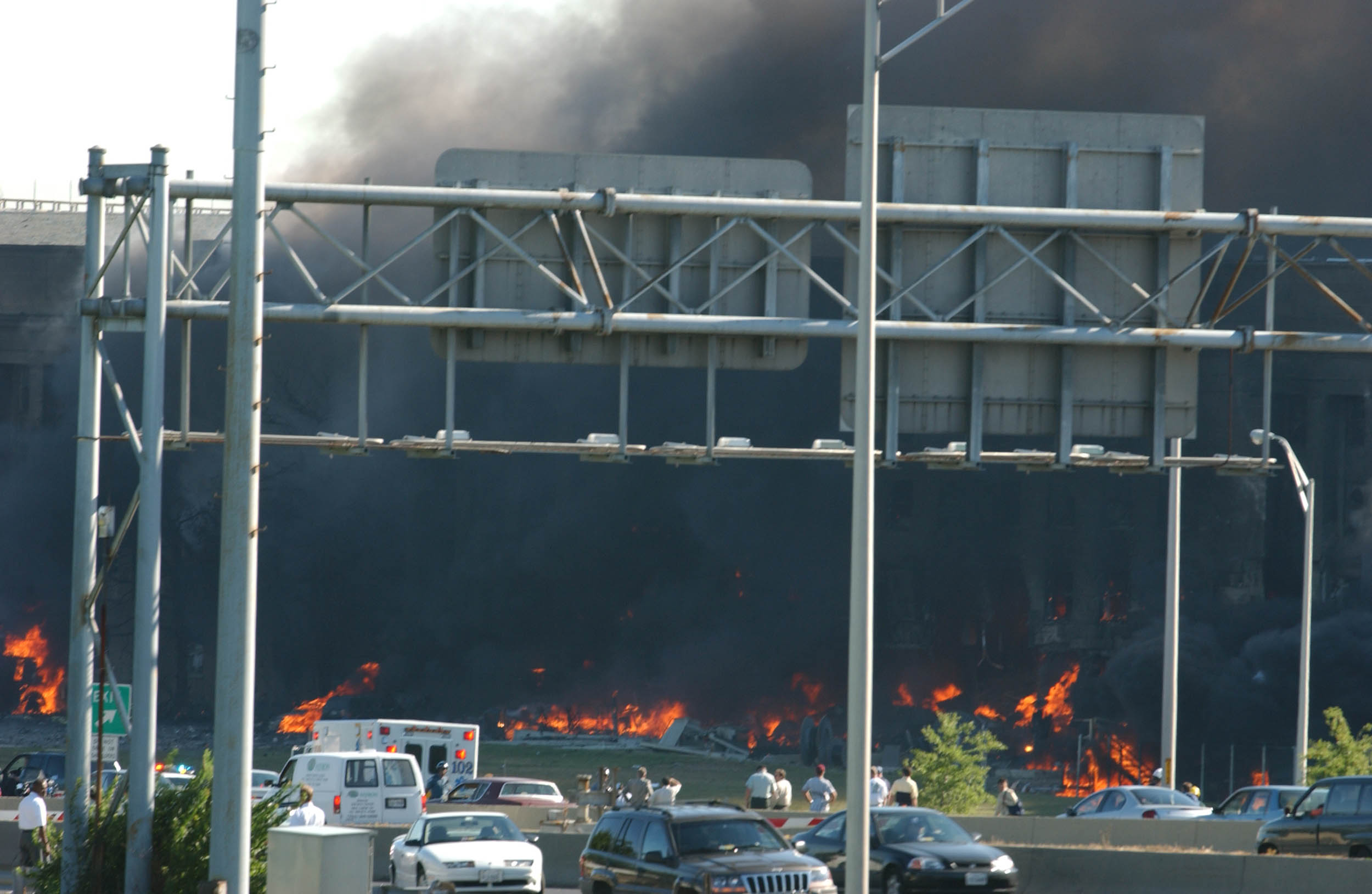 The
second shot was taken before the first and from the area of the
Navy Annex (the plane come over the top of the Annex on its way
across Route 27 and into the Pentagon). You can see the Pentagon on
fire from the initial strike and the building is still standing.
The small white car is the same from picture one. Some of the fires
in this picture are vehicles that were parked by the helo pad that
are on fire.
The
second shot was taken before the first and from the area of the
Navy Annex (the plane come over the top of the Annex on its way
across Route 27 and into the Pentagon). You can see the Pentagon on
fire from the initial strike and the building is still standing.
The small white car is the same from picture one. Some of the fires
in this picture are vehicles that were parked by the helo pad that
are on fire. The
third picture is when the first fire truck (from National
Airport) arrived and started its initial suppression efforts. To
the right you can see the diesel generator trailer (used to power
the control tower at the helo pad) on fire and the darker smoke as
the diesel fuel tank exploded and is fueling fires in that area.
Above the trailer you can see a white area of fire suppression foam
on the building right where the 4th corridor exits. You also notice
that the building is severely damaged as you can see the shift in
the granite facing, this is one of the hinge areas many see in later
photos posted elsewhere. Note that the grass and grounds of the
area are not gouged or disturbed. Recall that in the Khobar Towers
bombing, where a 20,000lb truck bomb took the face off of the
dormitory and killed 19 US Airmen, it truck bomb left a crater over
85 feet wide and some 25 feet deep. There is no such crater
present. Also note at the bottom of the picture, the concrete
"jersey" barrier behind the red car. Looking to the front of the
jersey you see the grey top of the guard rail that surrounds the
Pentagon on Route 27, it too has not been breached, meaning no truck
rammed through it to drive up to the building to detonate a vehicle
or truck borne explosive.
The
third picture is when the first fire truck (from National
Airport) arrived and started its initial suppression efforts. To
the right you can see the diesel generator trailer (used to power
the control tower at the helo pad) on fire and the darker smoke as
the diesel fuel tank exploded and is fueling fires in that area.
Above the trailer you can see a white area of fire suppression foam
on the building right where the 4th corridor exits. You also notice
that the building is severely damaged as you can see the shift in
the granite facing, this is one of the hinge areas many see in later
photos posted elsewhere. Note that the grass and grounds of the
area are not gouged or disturbed. Recall that in the Khobar Towers
bombing, where a 20,000lb truck bomb took the face off of the
dormitory and killed 19 US Airmen, it truck bomb left a crater over
85 feet wide and some 25 feet deep. There is no such crater
present. Also note at the bottom of the picture, the concrete
"jersey" barrier behind the red car. Looking to the front of the
jersey you see the grey top of the guard rail that surrounds the
Pentagon on Route 27, it too has not been breached, meaning no truck
rammed through it to drive up to the building to detonate a vehicle
or truck borne explosive. Picture
4 is a closer view of the hinge area of corridor 4 mentioned
previously. You can clearly see the fire suppression foam's loosing
battle against the aviation fuel. You also see the support columns
still holding the building together. The windows above are intact
because they're special blast proof windows designed to defeat a
large explosive - they worked well. The special windows were
installed during the renovation of the 4th corridor wedge by
strapping them directly into the original structure. You'll see
these windows in many of the published pictures. You are primarily
focused on the second floor of the building in this shot, the first
floor is obstructed by the stream of foam.
Picture
4 is a closer view of the hinge area of corridor 4 mentioned
previously. You can clearly see the fire suppression foam's loosing
battle against the aviation fuel. You also see the support columns
still holding the building together. The windows above are intact
because they're special blast proof windows designed to defeat a
large explosive - they worked well. The special windows were
installed during the renovation of the 4th corridor wedge by
strapping them directly into the original structure. You'll see
these windows in many of the published pictures. You are primarily
focused on the second floor of the building in this shot, the first
floor is obstructed by the stream of foam.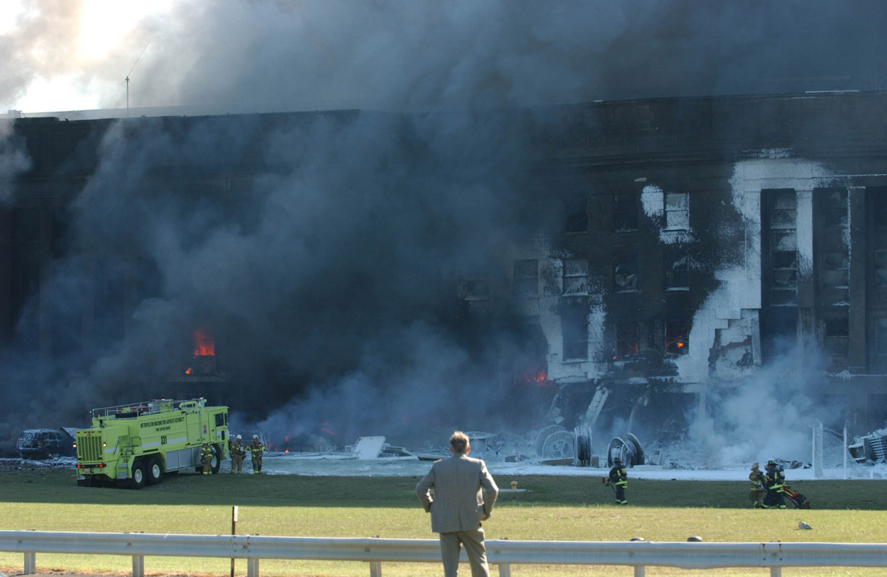 Picture
5 shows a view from the intact Route 27 guardrail. The fire
truck has run out of suppression foam and water. You see some of
the secondary fires are out (like the vehicles to the truck's left,
but the fires still rage inside the building still. You can see the
hinge area to the right and the sagging support columns along the
base of the building (REMEMBER: The building is five stories, but
on the outside E-Ring, the 5th floor does not have windows). You
can also see the pressure on the building by looking at the
difference in roof heights from the left side to the right. The
remaining columns are holding an immense amount of weight while at
the same time being weakened by the 1600+ degree fires. You can see
the difference in the size of the hinge area to the right from
previous photos. Just above the man's head and to the right you can
see the plane's impact hole that continues from the fire burning on
the second floor and extends to the left through the smoke and haze.
Picture
5 shows a view from the intact Route 27 guardrail. The fire
truck has run out of suppression foam and water. You see some of
the secondary fires are out (like the vehicles to the truck's left,
but the fires still rage inside the building still. You can see the
hinge area to the right and the sagging support columns along the
base of the building (REMEMBER: The building is five stories, but
on the outside E-Ring, the 5th floor does not have windows). You
can also see the pressure on the building by looking at the
difference in roof heights from the left side to the right. The
remaining columns are holding an immense amount of weight while at
the same time being weakened by the 1600+ degree fires. You can see
the difference in the size of the hinge area to the right from
previous photos. Just above the man's head and to the right you can
see the plane's impact hole that continues from the fire burning on
the second floor and extends to the left through the smoke and haze.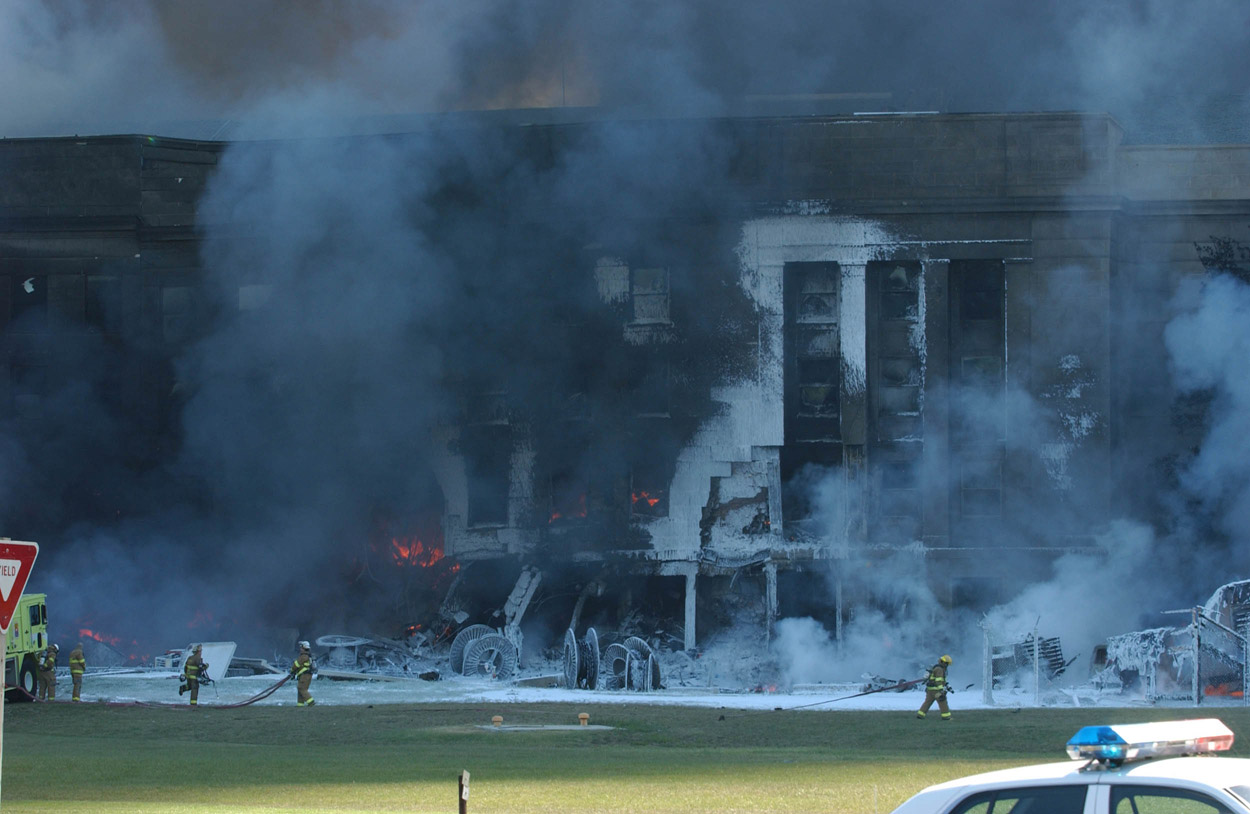 Picture
6 is a different angle of shot 5. Note there are no truck
marks on the grass area, nor any crater that would have been caused
by a truck bomb. The responding "crash" fire truck didn't make any
marks on the grass because it uses a much wider and lower pressure
tire than a regular truck. That allows the vehicle's weight to be
spread over a wider area so the truck can go into many more areas
than a normal truck. This contrasts with a rigid and thin truck
tire that would tear grass upon turning, or make depressions due to
lack of asphalt support. You can see wire bundles and other items
in the picture left over from the wedge renovations. The diesel
trailer is to the right of the rightmost firefighter. The top left
of the photo shows how much buckling is taking place from the right
side hinge area to the left joint where the building is about to
fall. The fire above the wire bundles is the opening the aircraft
made upon impact.
Picture
6 is a different angle of shot 5. Note there are no truck
marks on the grass area, nor any crater that would have been caused
by a truck bomb. The responding "crash" fire truck didn't make any
marks on the grass because it uses a much wider and lower pressure
tire than a regular truck. That allows the vehicle's weight to be
spread over a wider area so the truck can go into many more areas
than a normal truck. This contrasts with a rigid and thin truck
tire that would tear grass upon turning, or make depressions due to
lack of asphalt support. You can see wire bundles and other items
in the picture left over from the wedge renovations. The diesel
trailer is to the right of the rightmost firefighter. The top left
of the photo shows how much buckling is taking place from the right
side hinge area to the left joint where the building is about to
fall. The fire above the wire bundles is the opening the aircraft
made upon impact.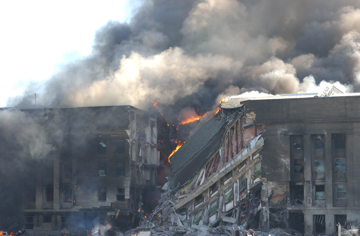 Picture
7 shows the E-ring building supports have failed and the
E-Ring in that area has collapsed. The backmost fires you see
raging are the fires from the collapsed roof that has failed and
folded back upon itself. Fires still rage in the rest of the
structure as well as inside the roofing. Look very closely at the
left wall sheer point (in the area where it is still standing), you
can clearly see where the second floor rear area of the E-Ring is
gone. That's the angle the plane took and the resulting damage.
Below that point and to the left is where the left engine and wing
area impacted and caused damage. That area also clearly shows
support columns' missing from where the aircraft engine's impact
sheered them away. Look at the green blast windows in the collapsed
area. They are those special windows that survived, and those
happen to be from the 3rd floor. Notice even in facility failure,
the windows are holding the face of the building and it's cross
columns together.
Picture
7 shows the E-ring building supports have failed and the
E-Ring in that area has collapsed. The backmost fires you see
raging are the fires from the collapsed roof that has failed and
folded back upon itself. Fires still rage in the rest of the
structure as well as inside the roofing. Look very closely at the
left wall sheer point (in the area where it is still standing), you
can clearly see where the second floor rear area of the E-Ring is
gone. That's the angle the plane took and the resulting damage.
Below that point and to the left is where the left engine and wing
area impacted and caused damage. That area also clearly shows
support columns' missing from where the aircraft engine's impact
sheered them away. Look at the green blast windows in the collapsed
area. They are those special windows that survived, and those
happen to be from the 3rd floor. Notice even in facility failure,
the windows are holding the face of the building and it's cross
columns together. Picture
8 is similar but again showing the intact guardrail and
undisturbed grass. You can see the diesel trailer is still on fire.
Witnesses believed it was clipped and damaged by the right wing of
the aircraft.
Picture
8 is similar but again showing the intact guardrail and
undisturbed grass. You can see the diesel trailer is still on fire.
Witnesses believed it was clipped and damaged by the right wing of
the aircraft.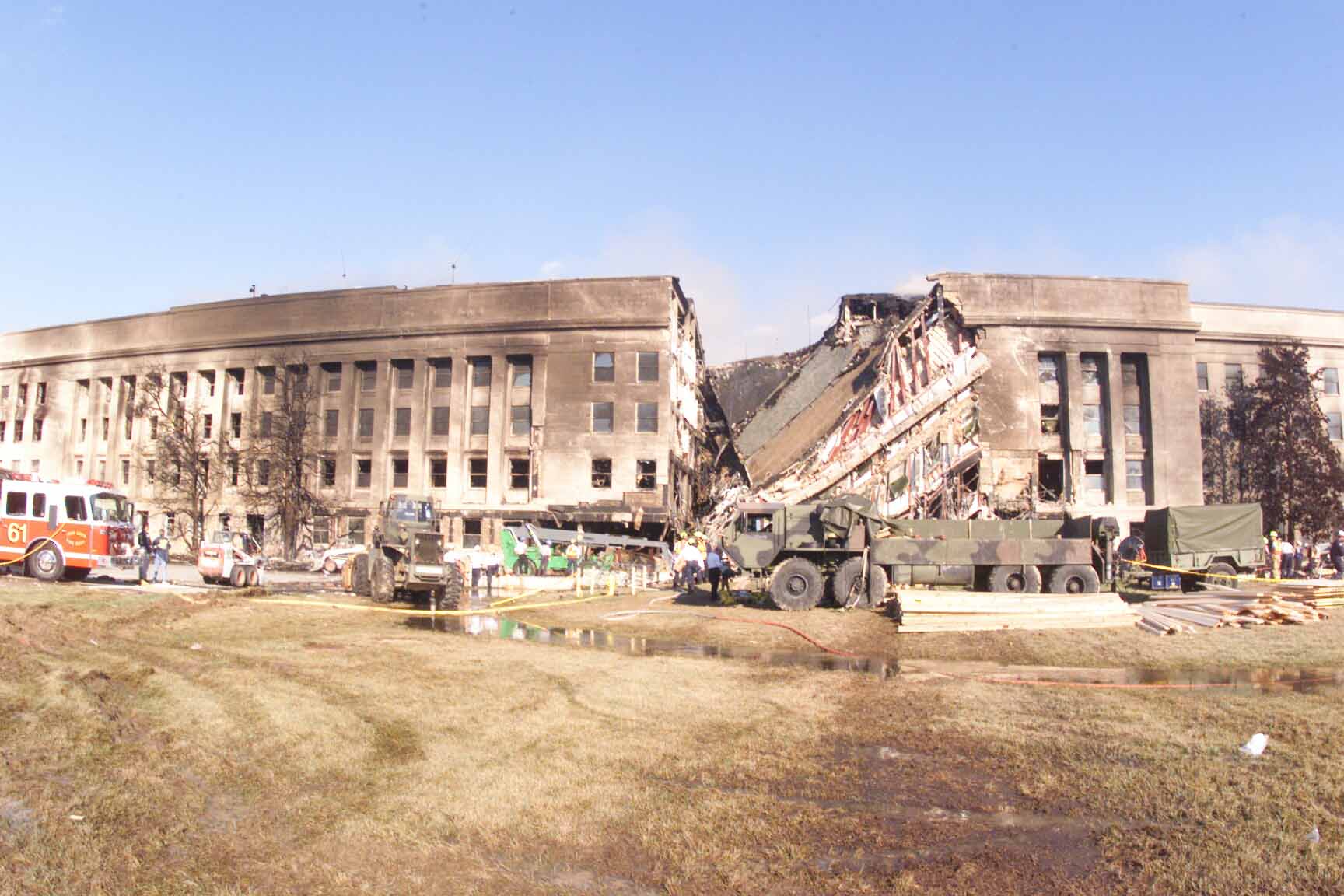 Picture
9 was taken after the fires on the E-ring had been
extinguished, but you can still see the smoke from the fires in the
roofing from the interior rings. You can see the amount of water
still present, as well as the heavy equipment starting to roll in
and bring shoring supplies so the threatened corner by the sheered
area can be propped up. You can also clearly see equipment in areas
where, if there were a truck bomb, there would be a huge crater.
You also see the tire marks the trucks are making in the grass. The
saturation of the grassy area by all the leaking and poured water
started to soften the area to the point where vehicles could have
become stuck and hampered the rescue efforts. There was a forecast
of rain for attack +2 that necessitated the building of sand and
gravel roads so all aspects of the rescue and recovery operations
could proceed. Anything less would have been unacceptable to the
families of the missing. Many believe the building of the roadways
was a cover-up for a crater or other reasons. If you look to the
left of the sheered area, you'll see (again) the missing support
columns where the plane impacted. Some of the hole is covered by
the boom of a light tower that is in the lowered position.
Picture
9 was taken after the fires on the E-ring had been
extinguished, but you can still see the smoke from the fires in the
roofing from the interior rings. You can see the amount of water
still present, as well as the heavy equipment starting to roll in
and bring shoring supplies so the threatened corner by the sheered
area can be propped up. You can also clearly see equipment in areas
where, if there were a truck bomb, there would be a huge crater.
You also see the tire marks the trucks are making in the grass. The
saturation of the grassy area by all the leaking and poured water
started to soften the area to the point where vehicles could have
become stuck and hampered the rescue efforts. There was a forecast
of rain for attack +2 that necessitated the building of sand and
gravel roads so all aspects of the rescue and recovery operations
could proceed. Anything less would have been unacceptable to the
families of the missing. Many believe the building of the roadways
was a cover-up for a crater or other reasons. If you look to the
left of the sheered area, you'll see (again) the missing support
columns where the plane impacted. Some of the hole is covered by
the boom of a light tower that is in the lowered position. Picture
10 shows another angle of the same shot. You can see the
sheered area which is the left most entry hole the aircraft. Again,
no blast crater is present indicating a vehicle borne explosive.
Picture
10 shows another angle of the same shot. You can see the
sheered area which is the left most entry hole the aircraft. Again,
no blast crater is present indicating a vehicle borne explosive.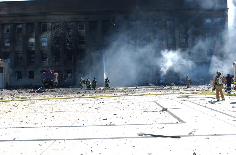 Picture
11 shows the helo pad to the left of the other shots. You
can see the plane's entry hole to the far right of the picture. You
can also see the severely burned fire truck (on the blast side) but
intact otherwise. The two firefighters had just finished waxing the
truck when they heard, then saw, the plane. They ran to the left of
this picture and were shielded from death by their very own fire
truck, which performed its last mission at that point by absorbing
the blast. This picture also starts to show the level of small
debris fragments that were the plane, and that cannot be seen in
other photos because of the depth of field of the pictures. I
speculate these parts were probably the remains of its left side
wing assemblies. There are similar amounts of small parts and
debris present throughout the entirety of the grass/helo pad area.
Picture
11 shows the helo pad to the left of the other shots. You
can see the plane's entry hole to the far right of the picture. You
can also see the severely burned fire truck (on the blast side) but
intact otherwise. The two firefighters had just finished waxing the
truck when they heard, then saw, the plane. They ran to the left of
this picture and were shielded from death by their very own fire
truck, which performed its last mission at that point by absorbing
the blast. This picture also starts to show the level of small
debris fragments that were the plane, and that cannot be seen in
other photos because of the depth of field of the pictures. I
speculate these parts were probably the remains of its left side
wing assemblies. There are similar amounts of small parts and
debris present throughout the entirety of the grass/helo pad area.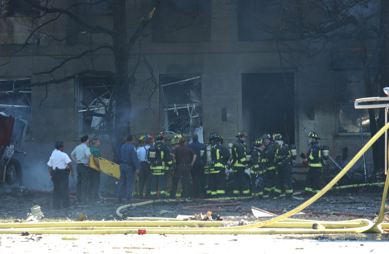 Picture
12 is a closer shot of the level of debris by the 5th
corridor side of the building.
Picture
12 is a closer shot of the level of debris by the 5th
corridor side of the building.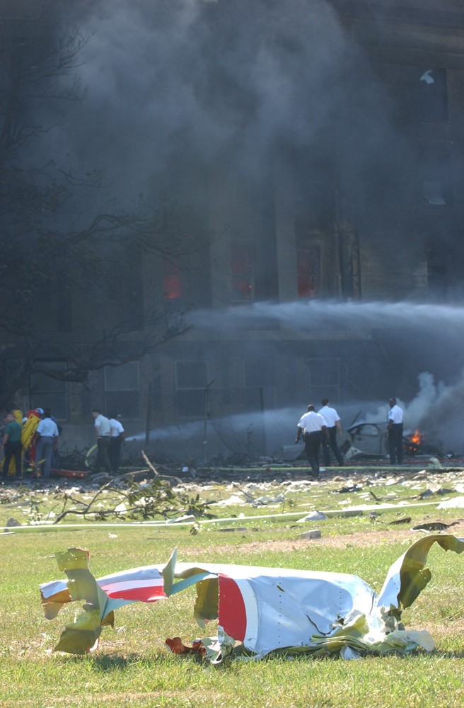 Picture
13 shows more of the debris field, including a twisted piece
of the American Airliner in front of the helo pad.
Picture
13 shows more of the debris field, including a twisted piece
of the American Airliner in front of the helo pad.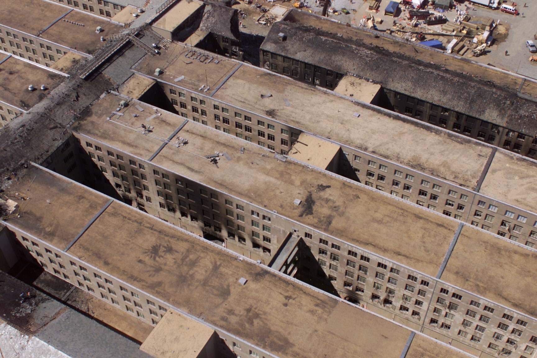 Picture
16 (and 17) are overhead shots of the building that shows
the impact area of the aircraft as well as the exit hole it made in
the C-Ring coming to rest in A&E Drive. The impact hole at the top
middle of the picture is clear. The exit hole is a bit trickier to
locate.
Start at the bottom right corner of the picture. Looking
at the row of windows from the corner,
Picture
16 (and 17) are overhead shots of the building that shows
the impact area of the aircraft as well as the exit hole it made in
the C-Ring coming to rest in A&E Drive. The impact hole at the top
middle of the picture is clear. The exit hole is a bit trickier to
locate.
Start at the bottom right corner of the picture. Looking
at the row of windows from the corner, 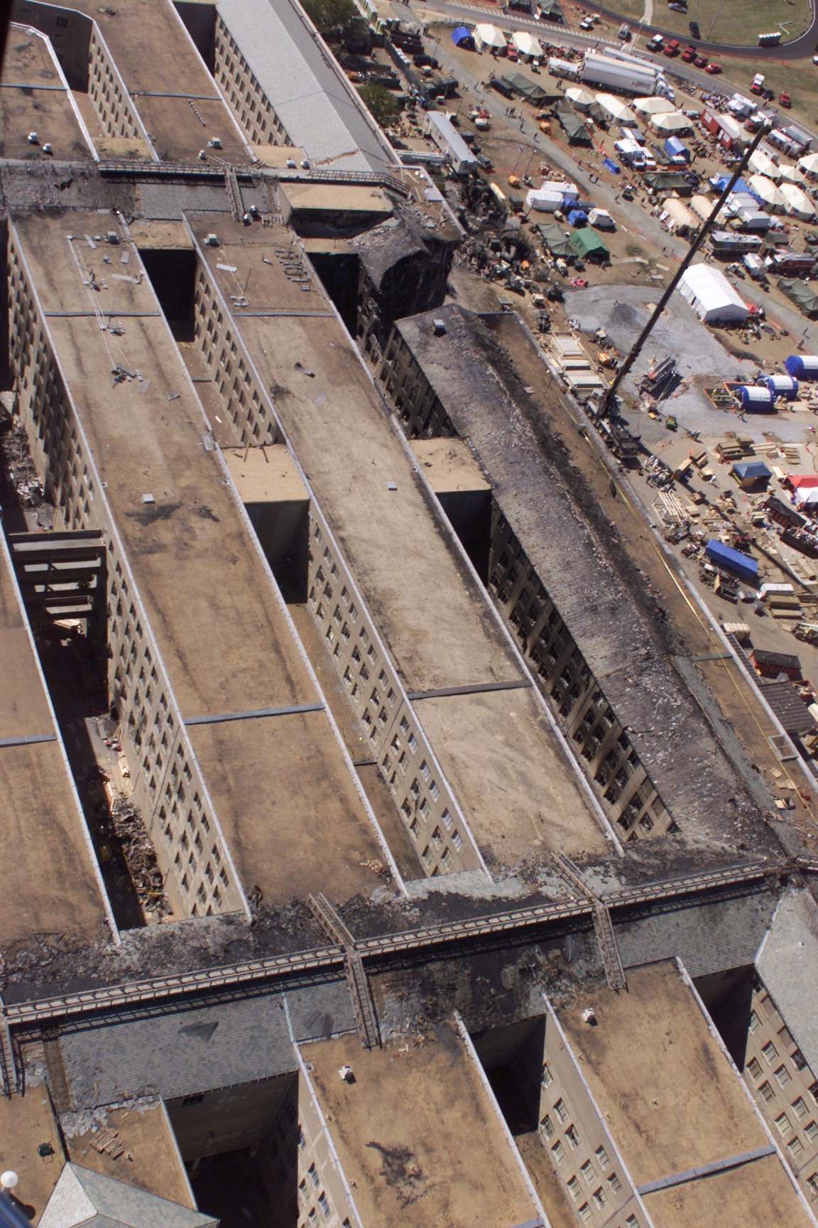 move left until you come to
the "trough" running between the rings. Go back to the right four
rows of windows and follow that down to the bottom floor (5, 4, 3,
2, then 1). You'll see a circular hole, that's the exit hole the
cockpit and front tire assembly made through the Navy Operations
Center. You'll note that the same areas to the right show no damage
on that ground floor. The open area to the right of the trough and
on the 1st floor is an area that was demolished to open another
avenue into the C ring, note that the hole is squared off to match
the exact size of the area between the support columns.
move left until you come to
the "trough" running between the rings. Go back to the right four
rows of windows and follow that down to the bottom floor (5, 4, 3,
2, then 1). You'll see a circular hole, that's the exit hole the
cockpit and front tire assembly made through the Navy Operations
Center. You'll note that the same areas to the right show no damage
on that ground floor. The open area to the right of the trough and
on the 1st floor is an area that was demolished to open another
avenue into the C ring, note that the hole is squared off to match
the exact size of the area between the support columns.